|
Mundell's Choice was the name given to his homestead by our immigrant ancestor, James Mundell, when he staked his original
claim. In transcribing documents for this page, I have spelled them exactly as they appear in the document.
Warrant for "Mundell's Choice"
WHEREAS James Mundal of the County of ________ hath requested to take up three hundred acres of land including an improvement
adjoining lines with James Seaton, Samuel Hyd, and Richard Ivers in the County of Washington (PROVIDED the same Land is purchased
of the Indians) for which he agrees to pay immediately into the Office of the Receiver General for the use of this State,
at the Rate of Ten Pounds per Hundred Acres, in Gold, Silver, Paper Money of this State, or Certificates agreeable to an Act
of Assembly, passed the First Day of April, 1784, Interest to commence from the first day of March 1781. THESE are therefore
to authorize and require you to Survey or cause to be Surveyed unto the said James Mundal at the place aforesaid according
to the Method of Townships appointed, the said Quantity of Acres, if not already surveyed or appropriated, and to make Return
thereof into the Secretary's Office in order for Confirmation, for which this shall be your Warrant. IN WITNESS whereof,
the Honourable James Irvine Esq, Vice President, of the Supreme Executive Concil, hath hereunto set his Hand and caused the
less Seal of the said Commonwealth to be affixed the nineteenth day of January in the year 1785. TO JOHN LUKENS, Esq. Surveyor-General.
Deed to land "Mundle's Choice"
The Supreme Executive Council of the Commonwealth of Pennsylvania.
To all to whom these presents shall come greeting.
Know ye in consideration of the monies paid by JAMES MUNDLE into the Receiver General's office of this Commonwealth at the
granting of the warrant hereinafter mentioned there is granted by the said Commonwealth, unto the said JAMES MUNDLE a certain
Tract of Land called "MUNDLE'S CHOICE" Situate on little Whitely Creek in Washington County, Beginning at a Jack Oak thence
by James Seaton's Claim, North forty six degrees, west, one hundred and twelve perches to about sixty eight degrees, west
ninety two perches to a white oak, south, forty four degrees west, sixty eight perches to about thencely, Elias Garrots claim,
South forty two degrees, east twenty four perches to a white oak, south twenty nine degrees, west one hundred forty eight
perches to a maple, thence by Richard Ivis claim, south thirty five degrees, East one hundred perches to a black oak, south
eighty degrees, fifty two perches to a white oak, Thencely, Aaron Judkins, north fifty degrees, East one hundred forty eight
perches to a white oak. West seventy one perches to a post, and north forty one degrees, east one hundred twenty perches
to the place of beginning. Containing two hundred forty two acres and one hundred twenty eight perches, an allowance of six
per cent for roads with the appurtenances which said tract was surveyed in persuance of a warrant granted to the said JAMES
MUNDLE, dated 19 Jan. 1785 To have and hold the said tract or parcel of land with the appurtances unto the said JAMES MUNDLE
and his heirs reservations as to mines, royalties, quit rents or otherwise excepting and receiving only the fifth part of
all gold and silver for the life of the Commonwealth to be delivered at the pits mouth clear of all charges. In witness thereof
his Excellency Thomas Mifflin, Edq. President of the Supreme Executive Concil (sic) hath hereto set his hand and caused the
State Seal to be affixed in Council the first day of March in the year of our Lord 1790 and of the Commonwealth the fourteenth.
Attest James Trimble
For Charles Biddle
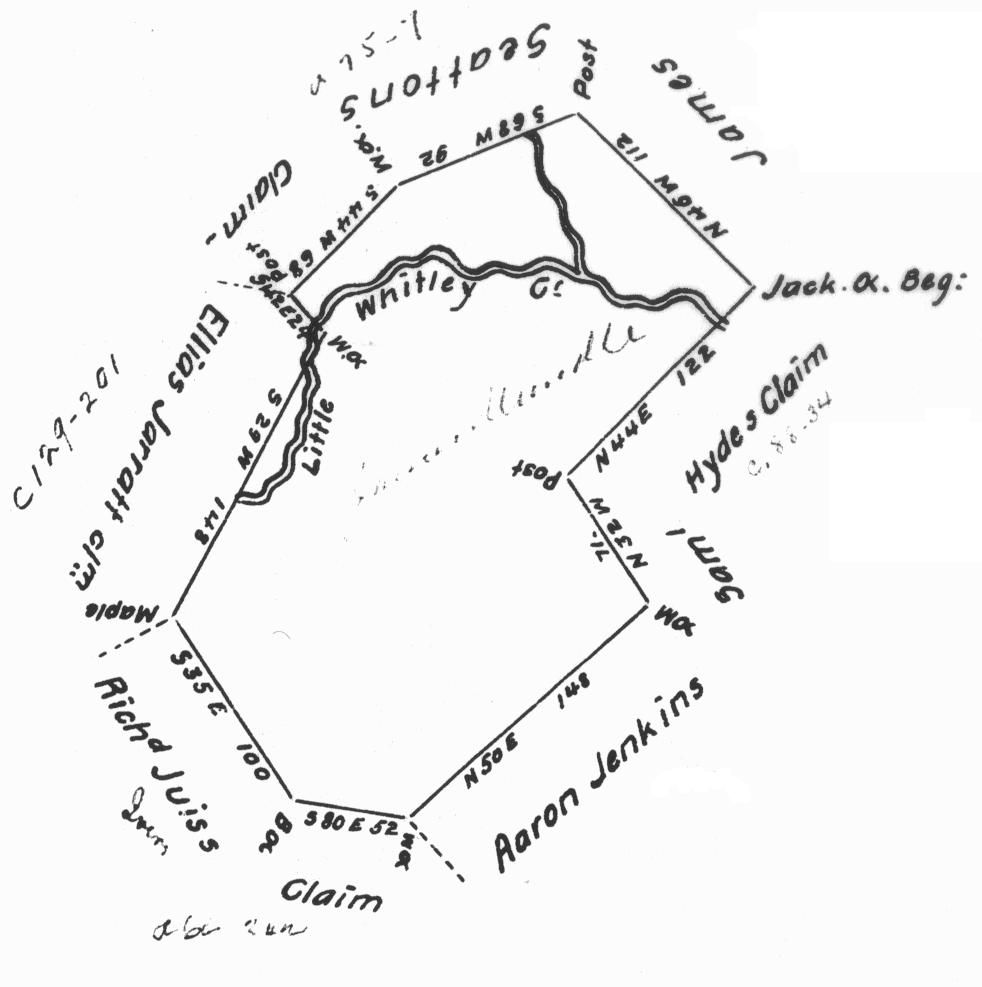
The first image is from a plat of a survey done of Mundell's Choice, and obtained from the Pennsylvania State Archives.
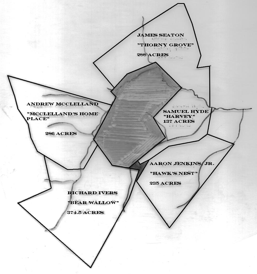
The
second image shows Mundell's Choice in the center and all the properties that surrounded it. Using information obtained in
the deeds for these six parcels, I was able to piece them together and place them on an official USGS map. To see either
image larger, click on the individual image.
|